

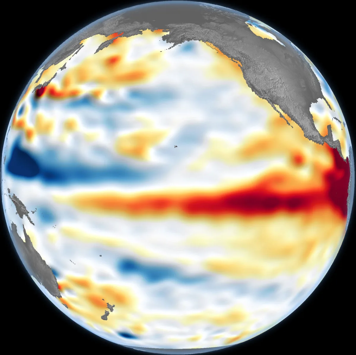
A massive climate shift is currently unfolding beneath the Pacific Ocean, and NASA satellites are tracking its expansion in real time. Following NOAA's official declaration of El Niño in June 2026, researchers are utilizing space-based altimetry to measure a critical hidden metric: sea surface height. The phenomenon was confirmed after sea surface temperatures remained at least 0.5 degrees Celsius (0.9 degrees Fahrenheit) above normal for several consecutive months.
However, surface temperatures only tell part of the story. Because warm water physically expands, a massive accumulation of subsurface heat causes the ocean's surface to rise. By measuring these subtle elevations, satellites can determine whether the developing El Niño possesses enough deep-ocean energy to fundamentally reshape global weather patterns later in the year.
Tracking Kelvin Waves from Space
The June 8, 2026, satellite map provided a clear visualization of this thermal expansion across the central and eastern Pacific. The data was captured by the Sentinel-6 Michael Freilich satellite, a joint mission launched in 2020 by NASA and the European Space Agency (ESA). By filtering out seasonal patterns and long-term sea level trends, scientists at NASA’s Jet Propulsion Laboratory (JPL) isolated the specific short-term signals driving the current climate anomaly.
The foundation for this event was laid earlier in the spring of 2026 when Sentinel-6 detected massive pulses of warm water, known as Kelvin waves, migrating eastward along the equator. These waves serve as an early sign that El Niño is forming. They typically emerge when the prevailing trade winds weaken or reverse, allowing warm water previously pooled in the western Pacific to surge back toward the Americas.
As these Kelvin waves travel east, they push the thermocline - the boundary layer between warm surface water and cold deep water - further down. This suppresses the natural upwelling of nutrient-rich, cooler water along the Pacific coasts, effectively capping the ocean with a deep, resilient blanket of heat that can sustain a prolonged climate event.
For now, it looks like it’s going to be a big one - more so than I would have said last week - but we still need more observations to know what’s going to happen.
- Séverine Fournier, Jet Propulsion Laboratory
The 1997 Benchmark and Winter Implications
The current data presents a complex forecasting challenge when compared to historical benchmarks. While conditions in the western Pacific closely mirror the early stages of the devastating 1997 El Niño, the eastern Pacific is currently lagging behind due to a slower arrival of Kelvin waves. This discrepancy highlights the volatile nature of ocean-atmosphere coupling.
If the pending eastward-moving Kelvin waves maintain their momentum, this deep reservoir of heat will lock in severe atmospheric disruptions for the upcoming Northern Hemisphere winter. A sustained event of this magnitude typically increases the probability of heavy rainfall across the U.S. Southwest, while simultaneously elevating the risk of severe drought in the western Pacific, including Australia and Indonesia.
Ultimately, the severity of the 2026 El Niño hinges on the depth of its heat storage rather than just its surface temperature. A thin layer of warm water can easily be disrupted by shifting winds, but the deep thermal blanket currently being tracked by Sentinel-6 suggests a resilient system capable of driving extreme global weather anomalies well into 2027.
This article was written by AI from reporting by scitechdaily.com.