In a striking demonstration of consumer technology bridging the gap between life and death, six skiers caught in a severe avalanche near Lake Tahoe were successfully rescued this week using the Emergency SOS via Satellite feature on their iPhone. This incident, occurring in a cellular dead zone within the Sierra Nevada mountains, underscores the maturing utility of satellite connectivity in mainstream smartphones, transforming what was once a niche feature for extreme explorers into a standard safety net for the average user. The rescue operation, coordinated by the Placer County Sheriff's Office, relied entirely on the digital distress signal beamed from the device to low-Earth orbit satellites.
The Mechanics of Satellite Rescue
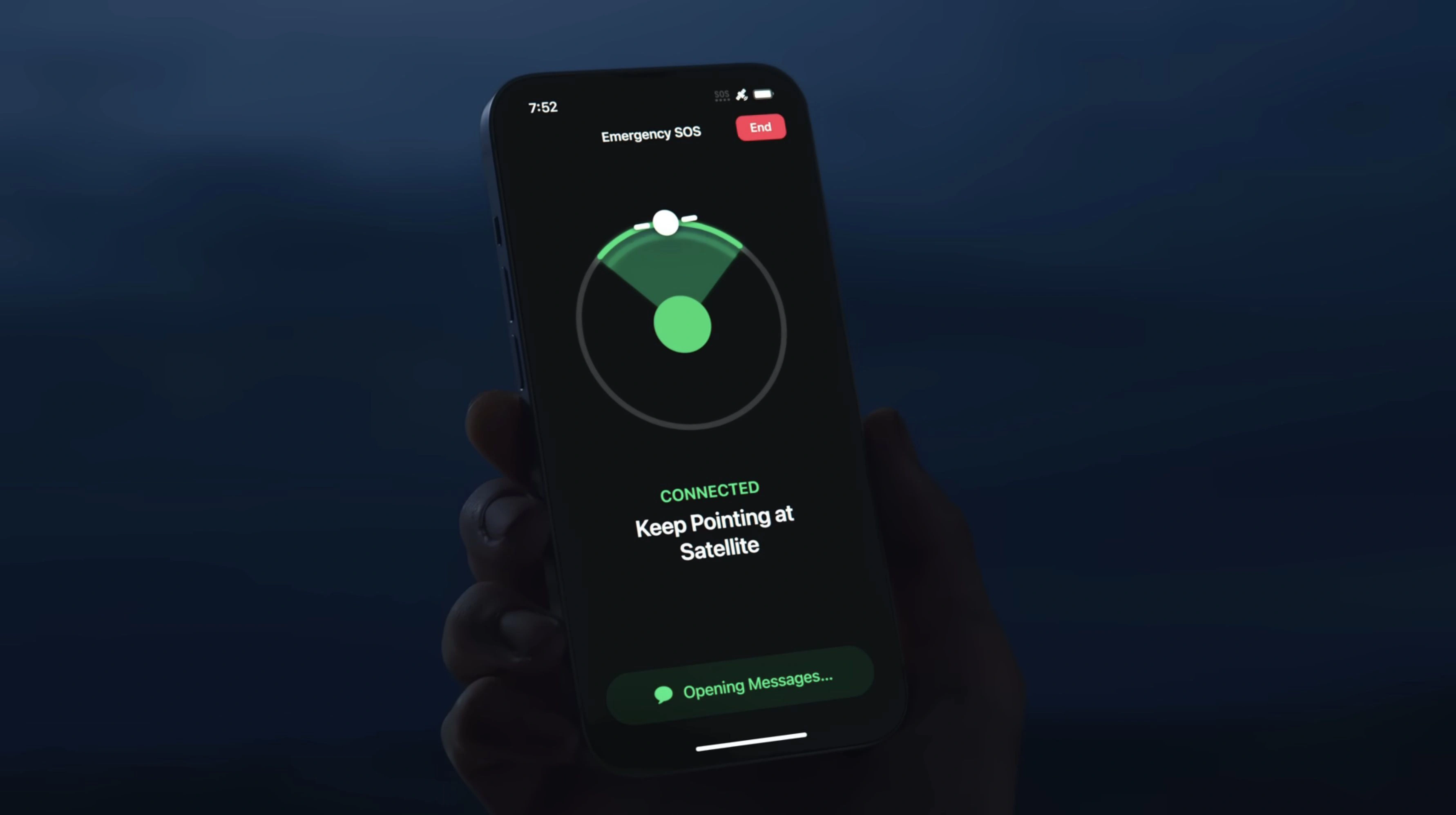
The success of this rescue was not merely a stroke of luck but the result of sophisticated hardware and software integration within the iPhone ecosystem. Unlike traditional cellular calls that rely on nearby towers, the Emergency SOS via Satellite feature utilizes the device's antennas to connect directly with satellites flying hundreds of miles above the Earth. Because these satellites move rapidly and have lower bandwidth compared to terrestrial towers, the iPhone guides the user via an on-screen interface to point the handset correctly, maintaining a 'line of sight' connection. This specific incident in Lake Tahoe highlights the technology's capability to function even in adverse weather conditions, provided there is a momentary break in the canopy or terrain obstruction.
Furthermore, the underlying data transmission protocol is engineered for extreme efficiency. Apple has developed a custom text compression algorithm that reduces the size of messages by a factor of three. This allows the distress signalcontaining the user's medical ID, precise latitude and longitude, and battery levelto be transmitted in as little as 15 seconds. In the case of the Tahoe skiers, this rapid data packet was received by one of Apple's ground relay centers, staffed by specialists who then verbally relayed the critical information to local emergency dispatchers who could not be reached directly.
Comparing Safety Tech: Smartphone vs. Dedicated Beacons
While the iPhone has proven its worth, it is essential to understand where it stands relative to dedicated Personal Locator Beacons (PLBs) and satellite messengers like Garmin inReach. The following table breaks down the technical differences for outdoor enthusiasts.
| Feature | iPhone Emergency SOS | Dedicated Satellite Messenger (e.g., Garmin) | Personal Locator Beacon (PLB) |
|---|---|---|---|
| Transmission Tech | L-band / S-band (Globalstar) | Iridium Network (Global Coverage) | 406 MHz (COSPAS-SARSAT) |
| Two-Way Comms | Yes (Text only) | Yes (Text & sometimes Weather) | No (One-way distress signal) |
| Battery Life | 1-2 Days (Phone dependent) | Days to Weeks | 5-7 Years (Standby) |
| Subscription | Free for 2 years (model dependent) | Monthly Fee Required | None (Govt. Search & Rescue) |
Strategic Implications for Outdoor Safety
The integration of satellite capabilities into consumer electronics represents a paradigm shift in search and rescue operations. Previously, skiers and hikers had to make a conscious decision to purchase and carry a separate, often expensive, device for emergencies. By embedding this technology into the iPhone, Apple has effectively democratized access to satellite safety. This Lake Tahoe incident serves as a potent case study for regulators and competitors alike, proving that non-terrestrial networks (NTN) are not just marketing gimmicks but essential utilities. As we move forward, we can expect this technology to expand beyond simple text SOS to potentially support voice and data, further closing the connectivity gap in remote regions.
Frequently Asked Questions
Does Emergency SOS via Satellite work automatically?
No, the user must actively trigger the feature when cellular and Wi-Fi coverage are unavailable. The interface then guides the user to align the phone with a passing satellite.
Is there a cost for using the satellite rescue feature?
Apple currently includes the service for free for two years with the activation of compatible iPhone models (iPhone 14 and later). Pricing structures after this period have not been fully detailed.
Can this feature work indoors or in a cave?
Generally, no. The technology requires a direct line of sight to the sky. Heavy foliage, deep canyons, or physical structures can obstruct the signal, though the protocol attempts to send data through gaps.
My Take
The rescue in Lake Tahoe is a definitive validation of the 'satellite-to-phone' sector. While dedicated PLBs still hold the crown for battery life and ruggedness, the best safety device is the one you actually have with you. Apple's implementation has successfully lowered the barrier to entry for satellite safety, likely forcing the entire mobile industry to adopt similar NTN standards by 2027. For outdoor enthusiasts, the iPhone is no longer just a camera; it is a legitimate survival tool.